Thursday, April 7, 2011
See You Later
This will be the last post on my blog, because I've come back home and my vacation is over. But I'm glad to be home--walking on the edges of tectonic plates is a bit dangerous compared to sitting in front of the TV. So I've been around the world, first stop Kathmandu, Nepal. Next I went to Sharm el-Sheikh, Egypt, and then La Paz, Bolivia. Finally, to San Mateo, California, and then back home to Seattle, Washington. Pictures were taken, dives were dived, mountains were climbed, and fireplaces were definitely used. But now I'm back home, and I bid thee adieu.
It's My Fault
Here I am, a bit closer to home, at the San Andreas Fault in California. I came to San Fransisco to find this North American Fault. It is a transform boundary of two plates--the North America Plate and the Pacific Plate. They move sideways against each other, shifting and creating many earthquakes. The fault changes all the time, creating extreme earthquakes. There are no volcanoes or mountains, just a fault that generates earthquakes, the most notable in 1857, 1906, 1989, and 2004. It produces magnitude 6.0 earthquakes about every 22 years. So, this place is really dangerous. The view in my tour is at 37°31'43.00"N, 122°21'44.00"W.
 |
| The San Andreas Fault http://upload.wikimedia.org/wikipedia/commons/0/04/Kluft-photo-Carrizo-Plain-Nov-2007-Img_0327.jpg |
Highest Capital City in the World
Now I've arrived in La Paz, Bolivia, the highest capital in the world. From the window of my hotel, I can see a long mountain range stretching from one horizon to the other--the Andes. An amazingly long range of mountains that lines the whole coast of South America, it is a volcanic arc. It was formed the same way as the Cascades and Mt. Rainier--one plate (Nazca Plate) moved under another (South America Plate) and heated up, turning into magma and then emerging as a volcanic arc. My view from La Paz (16 30'S, 68 09'W) shows the Andes Mountain Range. It is a Convergent Subduction Boundary, with many active volcanoes. Minor to major earthquakes occur to this day, along with volcanic eruptions.
 |
| Andes Mountain Range http://upload.wikimedia.org/wikipedia/commons/2/2f/Aerial_photo_of_the_Andes.jpg |
Diving
Right now, I am lying on my bed, typing in this post. I just spent an entire day exploring the reefs off the coast of the Sinai Peninsula in Sharm el-Sheikh, Egypt. I love to look at the coral and sponge while all the colorful, curious fish spin around me. I even saw a Brown-Banded Cusk-Eel slide gracefully past me and disappear into the distance. I managed to snap a few underwater pictures with my waterproof camera, but of all of them I like this picture the best:
A Red Sea Urchin in the Red Sea--how appropriate. A beautiful creature, this spiny urchin is an amazing sight in the reefs of the world's oceans and seas. I love to scuba dive, and diving in the Red Sea was definitely one of the highlights of my trip.
It was fun, but it was tiring. My eyelids are drooping as I type the words into this blog post, so I think it is about time I went to bed. Goodnight, all! Next time I post I'll be in La Paz, Bolivia.
 |
| http://petesfishplace.com/files/red_sea_urchin.jpg |
It was fun, but it was tiring. My eyelids are drooping as I type the words into this blog post, so I think it is about time I went to bed. Goodnight, all! Next time I post I'll be in La Paz, Bolivia.
Red
Let me first say, the water is warm. The scuba diving today was amazing, and as I climbed out of the Red Sea and went back to Sharm el-Sheik, Egypt, I realized I had just dived above a divergent boundary! Another tectonic boundary to check of my list. Here on the Sinai Peninsula in Asia, I can see the sea and the boundary under it: the Red Sea Rift. The Red Sea was formed when the Arabian Plate and the African Plate moved apart over millions of years. When they moved apart, new land came in and water flowed above it to create the Red Sea. For now, it is only a sea, but it is predicted that, since the boundary still widens very slowly, it may become an Ocean. A number of volcanic islands rise from the center, but most are dormant. In 2007, Jabal al-Tair Island erupted violently. Where I am staying, Sharm el-Sheik, is at 27°51'N, 34°16′E.
 |
| The Eruption of Jabal al-Tair Island in 2007 http://upload.wikimedia.org/wikipedia/commons/3/30/071001a-003.jpg |
Wednesday, April 6, 2011
Trapped
Well, folks, I have a bit of bad news. Kathmandu's airport got too snowy to fly planes in and out, so I'm stuck here until the weather gets better. It is still really cold, but I am having a good time. I decided to take a hike through the mountains, but I didn't dare climb either Everest or K2. I didn't last very long, because my coat was not warm enough. I ran back as fast as I could and sat down in front of the fireplace with a good book. So I will wait here until I can get out, and I can't wait--next I go to Egypt and the Sinai Peninsula! A beautiful place for scuba diving in the Red Sea, I'm going to vacation at Sharm el-Sheikh, Egypt, for two days while I observe the reefs of the Red Sea. My next post, hopefully, will be there. For now I wait.
 |
| I thought I would add a picture of my fireplace, virtually share the warmth. http://www.ci.yakima.wa.us/services/fire/images/fireplace.jpg |
Tuesday, April 5, 2011
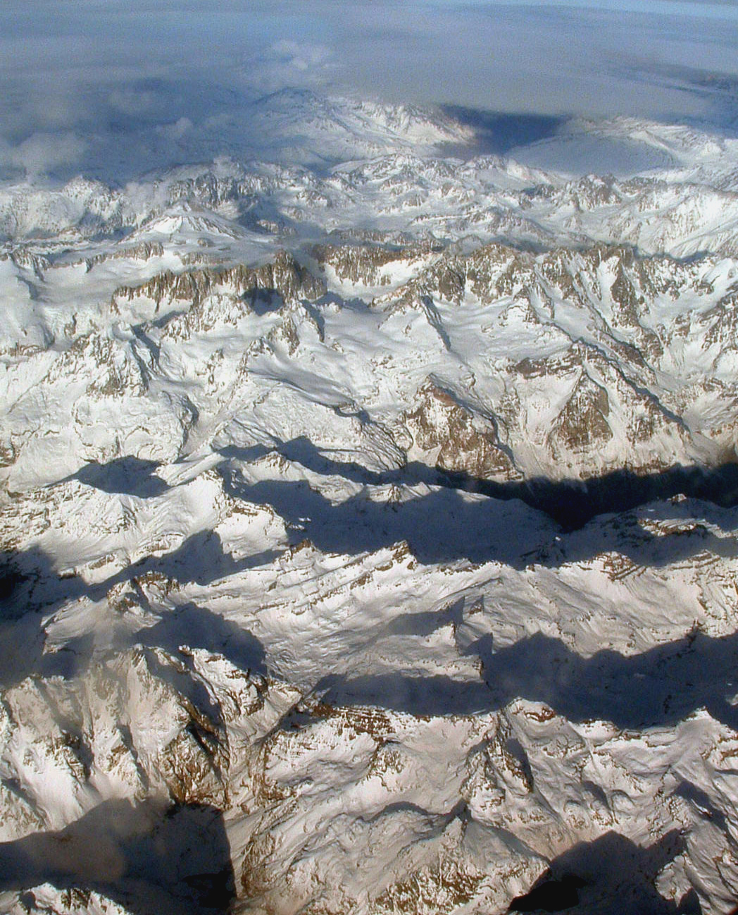
In the Himalayas
Here I am Kathmandu, Nepal, and it is freezing here compared to home! This place is in Asia, right on another convergent boundary of two tectonic plates. Specifically, the Indo-Australian Plate and the Eurasian Plate. This boundary, however, is not a subduction zone. Since the land plates of India and Asia collided, their light density meant both went up, creating a mountain range known today as the Himalayas. Kathmandu, where I'm spending the day, is in the Kathmandu Valley in the Himalayas, and I am here to observe. Now, along this boundary, it is a mountain range, but no volcanoes. Earthquakes happen from time to time, since the boundary is seismically active, but nothing has happened very recently. Mount Everest, the highest mountain above sea level, is at 27°59'17.00"N, 86°55'31.00"E.
 |
| Mt. Everest http://www.yahindnews.com/wp-content/uploads/2010/08/mount_everest.jpg |
Subscribe to:
Posts (Atom)